
How BIM construction management software bridges the gap between models and the field
The mechanical foreman pulls up the coordinated Building Information Modeling (BIM) model on his tablet, confirms his ductwork routing clears the structural beam, and tells his crew to start hanging. Two hours later, the first pipe hanger from the floor below collides with his duct because nobody modeled the hangers.
BIM construction management software is supposed to close exactly this kind of gap, and the cost of leaving it open is real.
Poor project data and miscommunication contribute to expensive annual rework in construction. The coordination happened on screen, but the distance between model and field turned into wasted labor and rework on the ground.
Here’s what this article covers:
- Why BIM models built for design fall short for field crews, and what makes them hard to use on the jobsite
- How mobile BIM access cuts RFI wait times and eliminates work stoppages
- Why field teams need both 2D and 3D views on the same device to avoid costly errors
- How linking BIM objects to tasks turns model data into actionable field work orders
- How crews can flag model-versus-reality discrepancies without stopping work
- Why field workers distrust BIM models they didn't build, and what actually builds confidence
- What happens to BIM access when connectivity drops, and why offline-first tools matter
It starts with understanding why the model your VDC team built may not be solving the problems your field crew actually faces.
Why BIM models built for design don't work for the people building the project
Design models often answer coordination questions without giving crews the field context they need to install work.
The most fundamental failure isn't technical. It's organizational. BIM models are built by office-based virtual design and construction (VDC) teams to answer design questions. They don't answer the questions a foreman asks while standing on a deck with a crew waiting for direction. Some teams try to rework architect models into something field crews can use. But most of the time, the model sits in the trailer and field teams walk right past it.
Design models often miss installation sequence and field-built components
Design-intent BIM captures geometry and spatial relationships but does not encode the order in which systems need to be installed. That gap can make a geometrically correct model actively misleading.
On coordinated projects, everything may fit in the model while still requiring a specific installation sequence that was never communicated. A ceiling plenum can look coordinated on screen and still fail in the field once crews are partway through assembly and run out of space.
Clash detection validates geometry, not buildability. Design models also often omit field-installed components, like pipe hangers and conduit supports, that occupy real physical space. If you don't model pipe hangers, the first one hung may get in the way of pipe below, negating the clash-detection effort entirely.
Large, data-heavy models are hard to use in the field
As BIM models accumulate data through design development, they become difficult to deploy in the field because data-rich models come with slower load times. A superintendent with a tablet on the jobsite can't wait for a large model to load while a crew stands idle.
Add interoperability issues on top: architects work in one authoring tool, structural engineers in another, MEP subs in a third. Construction-phase data often accumulates in separate systems or on paper. By the time the coordinated model reaches the people who need it most, it's reduced to 2D prints or static exports.
How mobile BIM access eliminates work stoppages
Mobile model access helps crews answer field questions without waiting on the trailer or office.
Every unresolved information gap on a jobsite turns into idle labor. RFI response cycles can stretch from days into weeks, and crews don't stop asking questions just because answers are slow.
Mobile BIM access can reduce RFI delays
When field teams can access model data on a phone or tablet, many questions can be resolved before they become formal RFIs. The payoff shows up in field productivity and time savings. Mobile field access reduces time lost to searching for information, waiting on callbacks, and walking back to the trailer for answers.
Putting answers at the point of work
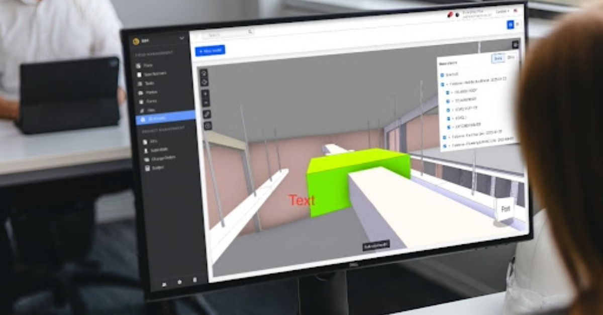
Fieldwire, a mobile-first, field-first jobsite management app backed by Hilti, lets trade and specialty contractors manage plans, tasks, and documentation from any device. Its BIM viewer lets field crews work with 3D models on their phones and tablets, access object metadata with a single tap, and take measurements to verify clearances on the spot.
When a foreman can confirm a dimension or check a clearance where the work is happening, that's one less phone call and one less crew standing around waiting.
Why field crews need both 2D and 3D views on the same device
Crews need both the contractual detail in 2D sheets and the spatial context in 3D models. Despite the growing use of BIM in preconstruction, on many projects teams revert to 2D drawings once work begins. Field teams often don't have consistent access to the information they need about what and where to build. When 3D and 2D data aren't accessible together, the back and forth increases the risk for confusion, misinterpretation, and errors.
Each format carries information the other can't
2D plan sheets carry the stamped dimensions, specification notes, and code-required callouts that govern what gets built and what inspectors verify. They're the contractual document of record. 3D models show spatial relationships: how a duct physically fits relative to the beam above it, the conduit beside it, and the sprinkler line crossing it.
A heating, ventilation, and air conditioning (HVAC) installer correctly following an approved 2D routing path can still install ductwork at the wrong elevation. Cross-system relationships visible only in the 3D model or a buried section detail are easy to miss on a plan sheet.
Embedded sleeve layout requires both 2D details and 3D context
The 3D model provides spatial understanding of how rebar, embed locations, and anchor bolts relate to formwork. The 2D detail provides the specific clearance requirements and tolerances the structural inspector will verify. A missed or mislocated sleeve after concrete placement can require core drilling or an engineered fix, depending on the structural conditions and engineer approval.
Fieldwire's BIM viewer addresses this directly with 2D-to-3D navigation. Field crews can switch between 2D plans and 3D model views on the same device, in the same project. A foreman can check the spec callout on the plan sheet and confirm the spatial fit in the model without switching apps or leaving the deck.

How linking BIM objects to tasks turns model data into field work orders
Model data becomes useful in the field when it is tied to assigned work. A BIM model full of intelligent objects means nothing to a field crew if those objects aren't connected to the work they need to do today. That intelligence only becomes useful when it's tied to a task: inspect this valve, verify this clearance, close out this punch item at this specific location.
Link model elements to punch list items
In Fieldwire, tasks are placed directly on plans, not in a disconnected to-do list. Tasks created within the 3D model carry location context and remain accessible from 2D plans. A punch list item logged against a specific model location carries its spatial context everywhere it goes: into reports, notifications, and the next foreman's morning walkthrough.
When new plan versions are uploaded, Fieldwire provides automatic version control, helping teams keep field context tied to the current sheet version.
Dispatch model-linked tasks as daily assignments
The real shift happens when model-linked tasks become the way field crews receive and track daily work. When a task is dispatched in Fieldwire, real-time push notifications go directly to the assigned team member's device. The task itself can include location, photos, checklists, and due dates. This turns the model from a reference document into an active jobsite management tool, and field teams save time when work is coordinated digitally instead of through paper handoffs.
How field crews flag model-versus-reality discrepancies without stopping work
Crews need a way to document field discrepancies without breaking production. Discrepancies between the model and field conditions surface when crews are mid-installation, not during pre-construction coordination. The question is whether flagging an issue requires stopping work or whether it can happen in the flow of production.
Documenting discrepancies at the point of discovery
A common field workflow starts when a foreman spots a condition that doesn't match the drawing. Without the right tool, that issue gets relayed verbally through the superintendent, the PM, and the VDC manager. With a mobile app, the foreman pins the issue to the exact plan location, snaps a photo, and adds a note. The right people get notified immediately, and the crew moves to the next task.
In Fieldwire, markups and tasks created on plans carry all the context the office needs to act: location, photos, annotations, and timestamps. Private markups let a foreman make personal notes invisible to the rest of the team. That's useful for flagging something for your own review before escalating.
Keeping the issue trail attached to the model
Reporting an issue is only half the job. The report needs to stay tied to the location, version, and context where it was found. When issues are pinned to plans or 3D model locations rather than buried in email threads, everyone working in that area can see what's been flagged.
Fieldwire's as-builts help teams keep a record of field markups, annotations, progress photos, and file links throughout the project. That project history stays attached to the work and supports closeout.
Why field workers distrust BIM models they didn't build, and how to close that gap
Field trust drops fast when the model does not match installed conditions. Field crews have good reason to be skeptical of BIM models. When following a model leads to rework because of a missed sleeve or a chase that doesn't fit, every future model gets treated with suspicion. That's evidence-based skepticism, and overcoming it takes more than better technology.
Where the trust breaks down
As RFIs, material substitutions, and field modifications pile up without being reflected in the model, it drifts further from what's actually being built. The people with BIM skills often lack field credibility, while the people with field authority can't operate the software.
What actually builds field confidence in the model
The strategies that work share one trait: they make field crews participants in planning and verification, not passive recipients of the model. Involving superintendents in model reviews before field deployment. Providing mobile access so crews can verify the model against real conditions at the point of work. And closing the feedback loop: when a field worker flags a discrepancy and sees the correction reflected, trust accumulates.
That feedback loop is central to how Fieldwire approaches field adoption. Teams use it to manage punch items at scale, accelerate closeout, and build consistent workflows across the jobsite.
What happens to BIM access when connectivity drops
Offline access matters because many jobsites lose signal where crews are actively working. Basements, tunnels, rural sites, and the interior of concrete structures all share one thing: unreliable or nonexistent cell signal. If your field information requires a live connection to function, those are exactly the places where your crew loses access to the information they need most.
Cloud-dependent platforms lose functionality without a signal
Many BIM platforms built for cloud-dependent workflows rely on workers manually downloading files before going offline and managing file states and sync when they reconnect. If a worker hasn't pre-downloaded a file, they may find only a placeholder on their device.
Offline-first tools flip that model. The app's primary data source is a local database, and connectivity is used for syncing, not for basic operation.
Offline-first tools keep field teams working without cell service
Fieldwire's offline functionality is built for exactly this situation. Field teams can access plans, tasks, markups, photos, checklists, and project files without a connection. When the crew reconnects, the project updates with all new data, team members are notified, and every piece of content added to tasks is timestamped. No manual toggle. Reduced reliance on placeholder files. Less risk of lost work.
For teams working on remote jobsites, this is the difference between a productive day and a paper-based fallback.
Closing the gap starts with the field
The model was never the weak link. The challenge has always been getting model intelligence into the hands of the people who actually build the project, in a format they can use, in conditions where it works, at the moment they need it.
That's the gap BIM construction management software needs to close. The answer is tools built for the field first, ones that reduce complexity rather than add to it.
Fieldwire Mobile BIM gives field teams and office staff a shared, real-time view of plans, tasks, and documentation. Everyone works from the same page, whether they're on the third floor or in the trailer.
The real test of any BIM tool is whether crews actually open it in the field, not whether it looks polished in coordination. Fieldwire's free Basic plan lets you put the core field workflow in front of your crew on a real project and see whether they adopt it before you commit budget.


